I pulled into Bald Eagle State Forest from the Mile Run Road exit (exit 199) off of I-80 in West Buffalo Township, PA. Heading south on Mile Run Road, it didn’t take long for the blacktop to end – perhaps only 1/4 of a mile. That is where Mile Run Road dead ends into White Deer Pike, which is a well maintained gravel road.
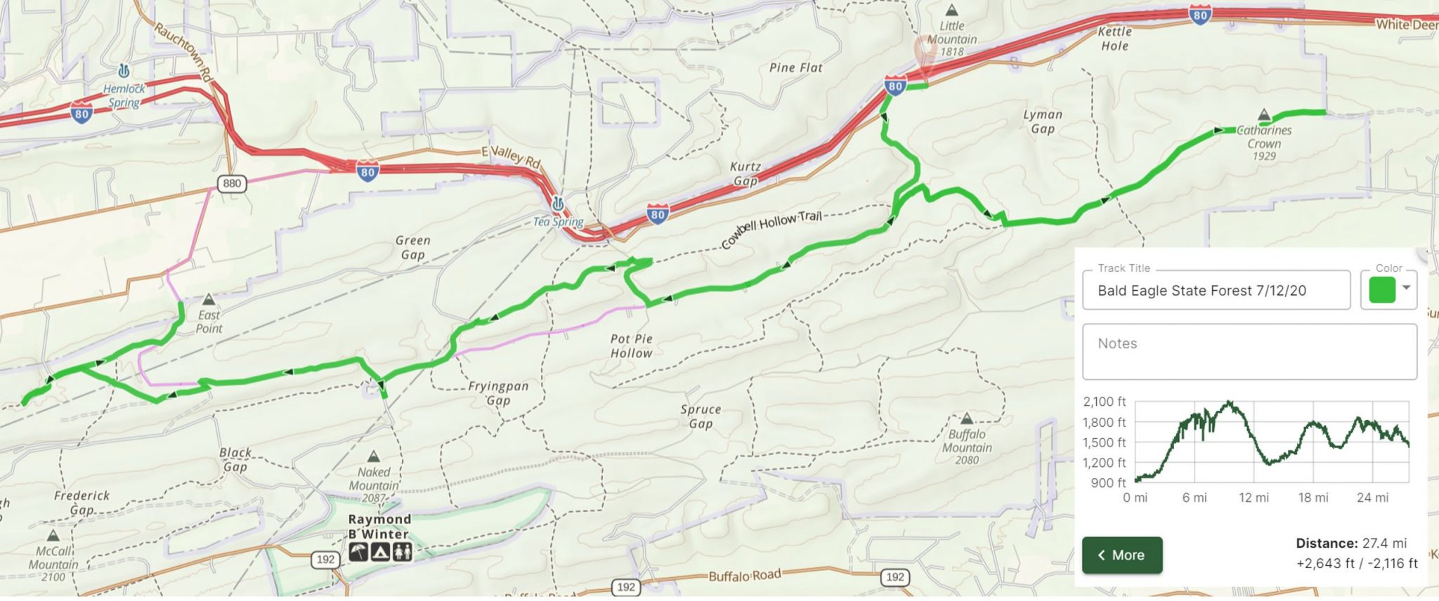
I headed west on White Deer Pike and took the first left (heading south) onto White Deer Creek Road, another well maintained gravel road. Both roads so far were nothing special from an off-roading perspective.
At the first bridge over the creek, I was greeted by a beaver sunning himself in the middle of the road. I stopped, tried to snap a usable picture from my digital SLR, but I quickly realized that I had the wide-angle lens on the camera. The pictures I took of the little guy were from far away, unfortunately.
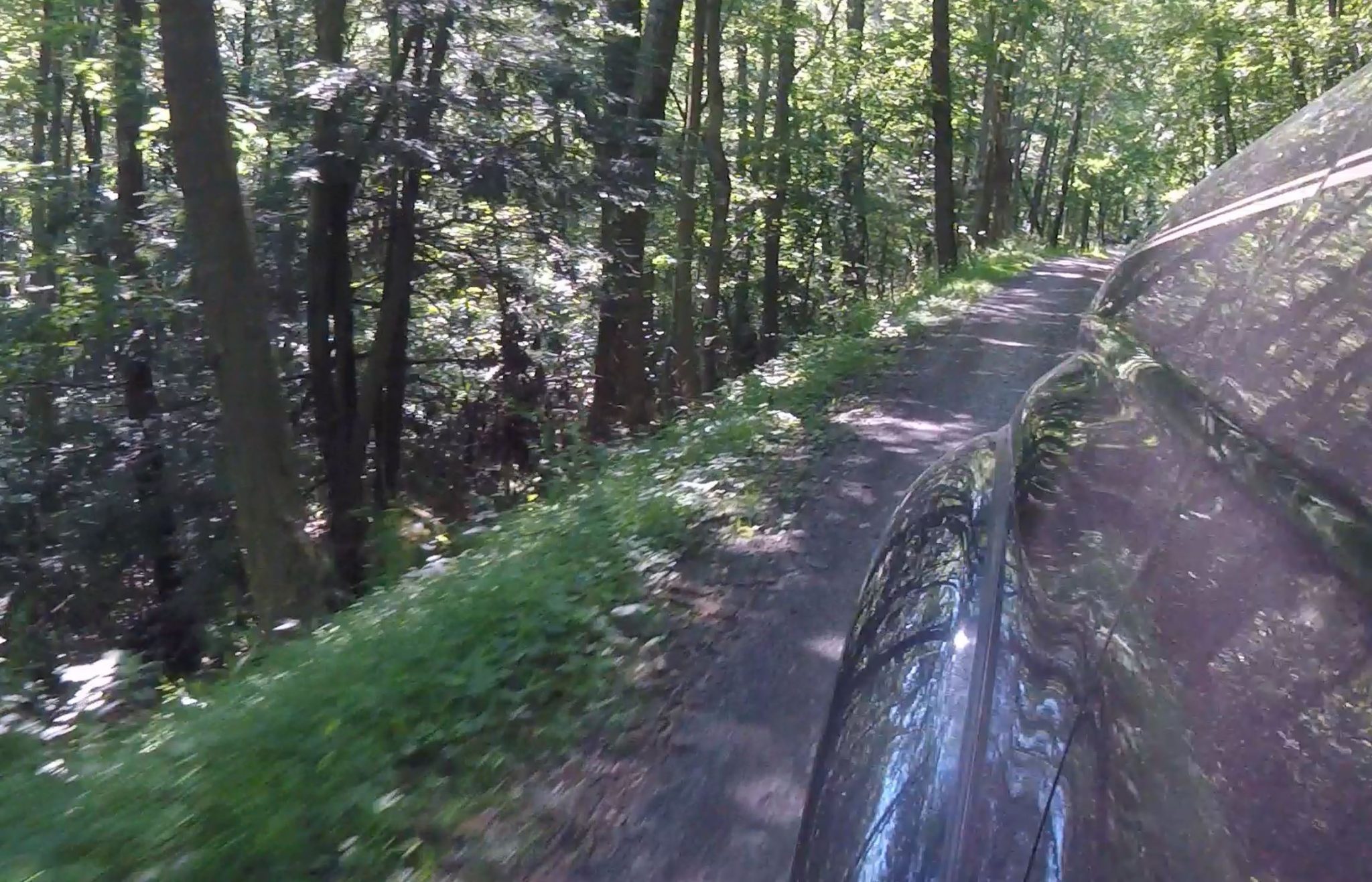
I continued south on White Deer Creek Road and took a hard left onto Running Gap Road. I was now headed east to higher elevations, relatively speaking, of course. We are talking about just a little higher than 2000 ft. Running Gap road was also a well maintained gravel road and I was itching to get into some rougher terrain. The road was scenic with the drop off on the driver’s side door.
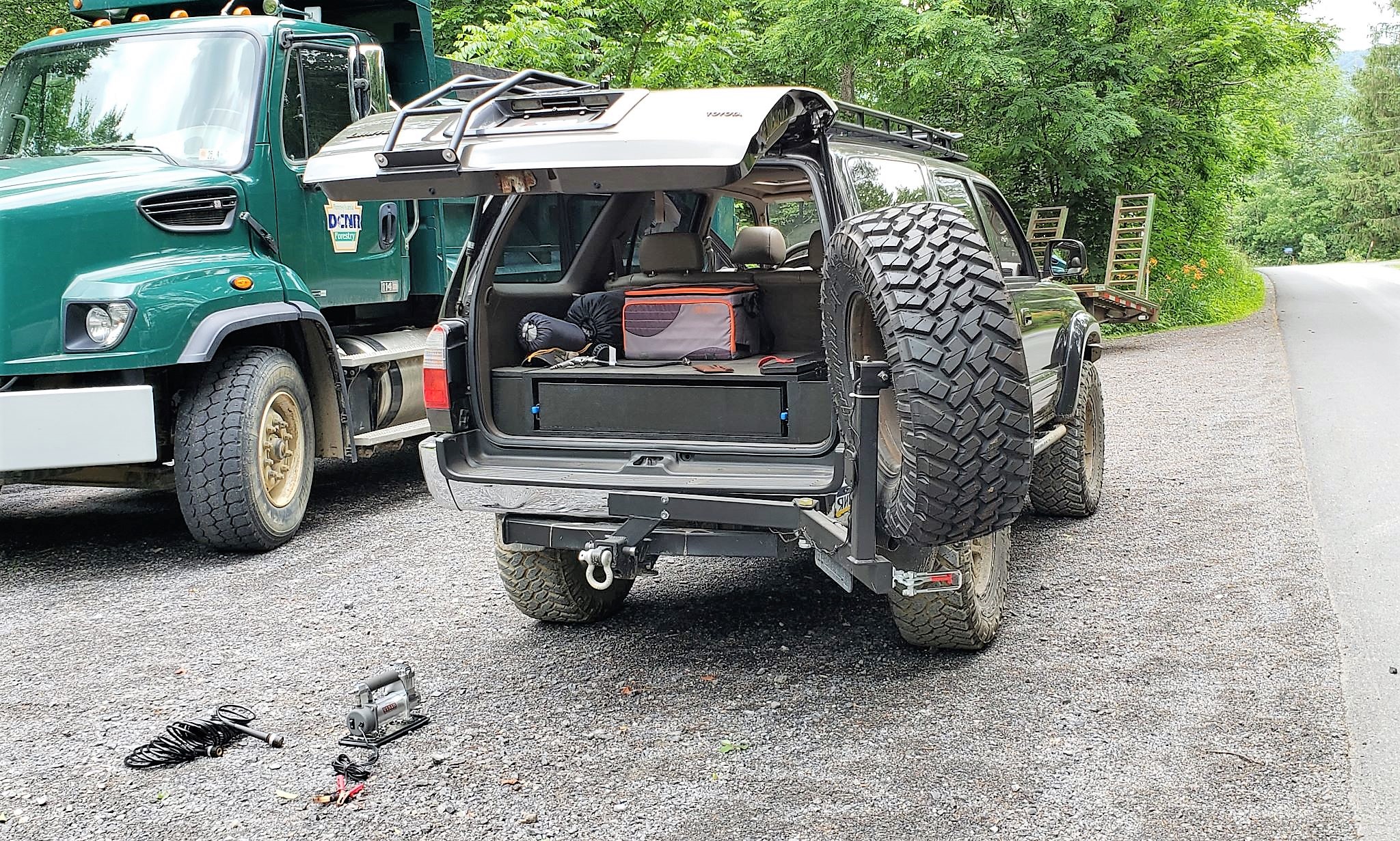
Once I arrived at the cross road of Running Gap Road and Nittany Mountain Trail, I stopped for a bit to air-down my tires. My Purple Lizard map designates Running Gap Road as a high-clearance 4wd road and I knew, at least, that there would be some rocks. I wanted to take some of the stress off my 4Runner (and my back), so airing down seemed like the prudent thing to do. Nittany Mountain trail looked to be a dead end road on the Purple Lizard map and on the Gaia GPS. The sign at the start of the trail confirmed as much. Looks to be 4 miles in and 4 miles out.
Nittany Mountain trail was nice enough for some easy off-roading. It was wide enough in most spots. Rocky terrain mixed with some wet areas from the heavy rain the day before. I took it all the way to the end and the end was marked with a makeshift rock wall that spanned two posts that were remnants of a gate that was probably torn down some time ago. The gate was to officially mark the edge of Bald Eagle State Forest, but the trail continued on. I wanted to explore more of Bald Eagle, so I did a 5-point turn and headed back the other way. On my way back down Nittany Mountain Trail I did run into a hiker headed east. I crawled to a roll and said hi through the open window as he stood to the side to let me pass. He didn’t seem much interested in talking, so we both headed our own way.
After backtracking back to White Deer Creek Road, I took a left and headed deeper into the forest. I stopped at one of the primitive campsites along the road to see what they have to offer. Nothing special. Some had fire rings and/or picnic tables. Others had nothing. Just a clearing. Pretty much what you would expect.
The route I planned before I arrived had me continuing on down White Deer Creek Road, but I looked at my Purple Lizard to try to find another high-clearance 4wd road. I took a right onto Cooper Mill Road until I got to Duncan Trail. I took a left (heading west and parallel to White Deer Creek Road) on Duncan Trail, which was an overgrown, tight off-road trail. Not much scenery or challenge, but better than driving down a manicured gravel road. Duncan Trail dead ended into a primitive campsite along Harden Hollow Road. I took this as an opportunity to eat some lunch and to fill up my water bottle from the cooler. After lunch, I took a left (headed south) on Garden Hollow Road (maintained gravel) and then a right (headed west) back on White Deer Creek Road to where it ended at McCall Dam Road, where I took a right (headed west).
My preplanned route had me stay on McCall Dam Road, taking me out of the forest and on to blacktop. I wasn’t ready to end my day yet and wanted to get back on another high-clearance trail. I took a left (south) on Engle Road and then a right (west) on Heintz Trail which took me to a trail that ran along the high voltage overhead powerlines. I have been on some powerline trails before, but none quite as up and down as this one. This was the most hair-raising part of my day and it was a ton of fun. I took the powerline trail northwest until I came to Swenks Road, where I took a left (west). I followed Swenks Road (maintained gravel) until it turned into basically a double-track trail and dead-ended. With not much room to maneuver, I did a 5-point turn (maybe it was seven, given how tight the trail was) and then headed back east down Swenks Road until it dead-ended into McCall Dam Road. I took a left (north) and was back on my preplanned trail and on my way out of the forest.
I got back to blacktop, pulled over next to a forestry truck and aired my tires back up for the drive home. On my way back to I-80, I was surprised to see I was in Amish country. Many horses and buggies on the country road on a Sunday afternoon. I took it slow and ensured there was a great amount of distance between me and their horses, as not to spook them, and was back on the highway before I knew it.
All in all, it was a fun day for my first time off-roading in the area. There are so many forests and tons of other trails in this part of Pennsylvania and I need to explore more of it. I am going to try to find some areas that have more high-clearance or minimally maintained roads and less maintained gravel ones. I would also like to plot out a trip with scenic opportunities as this one didn’t provide much to see.